Geology
Lanzarote Volcanoes: Timanfaya's Eruptions and the Craters to Walk
Almost everything a visitor sees of Lanzarote’s volcanoes comes from two episodes. The first is the great eruption of 1730 to 1736, which went on until April 1736 and covered about a quarter of the island. The second is a shorter burst in 1824, the last eruption on Lanzarote. Timanfaya National Park protects the heart of the older lava field, the Montañas del Fuego or Fire Mountains, where the ground at Islote de Hilario is still hot enough to set dry plants alight.
For planning, the key point is this: the Fire Mountains inside the national park are seen from the park’s Volcano Route bus, not on foot. To walk on a volcano, go to the natural park that surrounds it. There, signed trails lead into the crater of Caldera de Los Cuervos, where the eruption began in 1730, around Montaña Colorada, where it ended, and up to the rim of Caldera Blanca. For lava tubes, you need the far north of the island. This article explains the eruptions, the main volcanoes, the heat under Islote de Hilario and which of them you can reach.
Lanzarote’s volcanoes at a glance
- The great eruption: from 1 September 1730 to April 1736. It began at Caldera de Los Cuervos and ended at Caldera Colorada, the cone that Tinajo’s trail network calls Montaña Colorada.
- The last eruption: 1824, when three new volcanoes formed: Tao, Volcán Nuevo del Fuego (also called Chinero) and Tinguatón. The activity stopped around 25 October.
- Are they active? The park’s history page says that after 1824 Lanzarote’s volcanoes entered a period of calm. The heat under Islote de Hilario, the highest thermal anomaly in the Canary Islands, has not gone away.
- Where to see them: the Montañas del Fuego inside Timanfaya National Park (by bus), the Parque Natural de Los Volcanes around it (on foot), and the La Corona lava tube in the north (Cueva de los Verdes and Jameos del Agua).
- Volcanoes you can walk: Caldera de Los Cuervos and Montaña Colorada (about 1 hour each, low difficulty), Caldera Blanca (about four and a quarter hours), and the park’s own free guided walk at Tremesana.
Two parks, one volcanic landscape
It helps to know that Timanfaya’s volcanoes sit in two protected areas with different rules.
Timanfaya National Park covers 5,107 ha of almost untouched lava from the eruption of 1730–36: in the national parks service’s description, almost a quarter of the area the eighteenth-century eruptions affected. It receives more than half a million visitors a year, according to the Yaiza council. Access is tightly controlled: you drive to Islote de Hilario and see the core of the park from a bus. Our guide to Timanfaya tickets and the Volcano Route explains how that visit works.
The Parque Natural de Los Volcanes is the broad band of lava around the national park, bordering the sea to the west. It covers about 10,158 hectares in the municipalities of Yaiza, Tías and Tinajo. The Cabildo’s plan for the natural park names the places inside it: the Charco de Los Clicos at El Golfo, Montaña Colorada, Caldera Blanca, Volcán del Cuervo and Los Hervideros. This is where the walking trails are.
Both parks protect the same eruption. The line between them is administrative, not geological, so most walks in the natural park cross the lava of 1730–1736.
The eruption of 1730–1736
The night it began
The best-known account of the eruption is the manuscript of Andrés Lorenzo Curbelo, the parish priest of Yaiza, quoted on the park’s history page. In his words, on 1 September 1730, between nine and ten at night, the earth suddenly opened near Timanfaya, two leagues from Yaiza. On the first night a huge mountain rose, and flames escaped from its top for nineteen days.
The Lanzarote geopark identifies that first vent as the Caldera de Los Cuervos, the cone formed on 1 September 1730 that began the eruption. The Tinajo council adds what it destroyed: the village of Chimanfaya and the surrounding farmland, known as the Vega de Las Vacas, where grain was grown.
Villages under the lava
Curbelo’s account reads like a diary of loss. The lava at first ran as fast as water, but soon slowed until it flowed no faster than honey. On 7 September a large rock rose from the ground with a noise like thunder and forced the lava to change course, and it destroyed the villages of Maretas and Santa Catalina in an instant. On 11 September the eruption resumed with more force. Lava from Santa Catalina fell on Mazo, burned and covered the whole village, and ran on to the sea for six days in a row. Large numbers of dead fish floated on the surface and washed up on the shore. On 18 October three new vents opened just above Santa Catalina.
The eruptions did not stop, and Curbelo’s account runs until the people of the area emigrated, between 1731 and 1732. Inland, the geopark notes, the lava filled the old valleys and wiped out wide areas that had been used for growing cereals.
How it ended
The last cone of the eruption was Caldera Colorada, built in the final phase in April 1736. The Tinajo council, which calls it Montaña Colorada, says its lava flowed north and threatened the village of Tinajo. After the eruption ended, a shrine to the Virgen de Los Dolores was built where the lava stopped.
The geopark describes Los Cuervos and Caldera Colorada, which stand close together, as the start and end of the largest historical eruption in the Canaries.
The scale
The numbers explain why the landscape still looks raw:
- Area: the eruptions of 1730–1736 covered about a quarter of the island. The Canary Islands government’s park site puts the sea of lava at about 174 km²; the geopark gives about 176 km². The small difference is between the two sources, not a change on the ground.
- Thickness: deep boreholes show the lava piled up to 100 m thick in places.
- Volume: scientists have estimated that the lava may have reached 1 cubic kilometre, completely changing the island’s former shape.
- Reach: part of the lava drained west to the sea and gained land from it. Other flows reached as far as the port of Arrecife, and some are preserved inside the Monumento al Campesino.
1824: the last eruption
Almost a century later the ground opened again. The eruptions began on 31 July 1824 at the Tao volcano and were described by an eyewitness, Baltasar Perdomo, the priest of San Bartolomé. Three volcanoes formed: Tao, Volcán Nuevo del Fuego and Tinguatón.
Volcán Nuevo del Fuego, better known as Chinero, formed in the second episode, between 29 September and 5 October, about 13 km from Tao. Its lava travelled 7 km to reach the sea. It is the only volcano of that phase inside today’s national park. The activity ceased around 25 October.
The geopark calls Chinero the last historical eruption on the island. After it, in the words of the park’s history page, Lanzarote’s volcanoes entered a period of calm.
The Montañas del Fuego
The Montañas del Fuego are the core of the park, where the most important eruptions took place. The Canary Islands government’s park site counts 25 craters there; the national parks service says more than 25 lie within a few square kilometres. A few names are worth knowing:
- Calderas Quemadas, a line of volcanoes that marks the main direction of the fissure that fed the eruption.
- El Corazoncillo, a ring volcano whose crater lies 100 m below the outer base of the cone.
- The Manto de la Virgen, the most characteristic hornito in the park. Hornitos are small secondary vents that spat lava and gas without building a large cone.
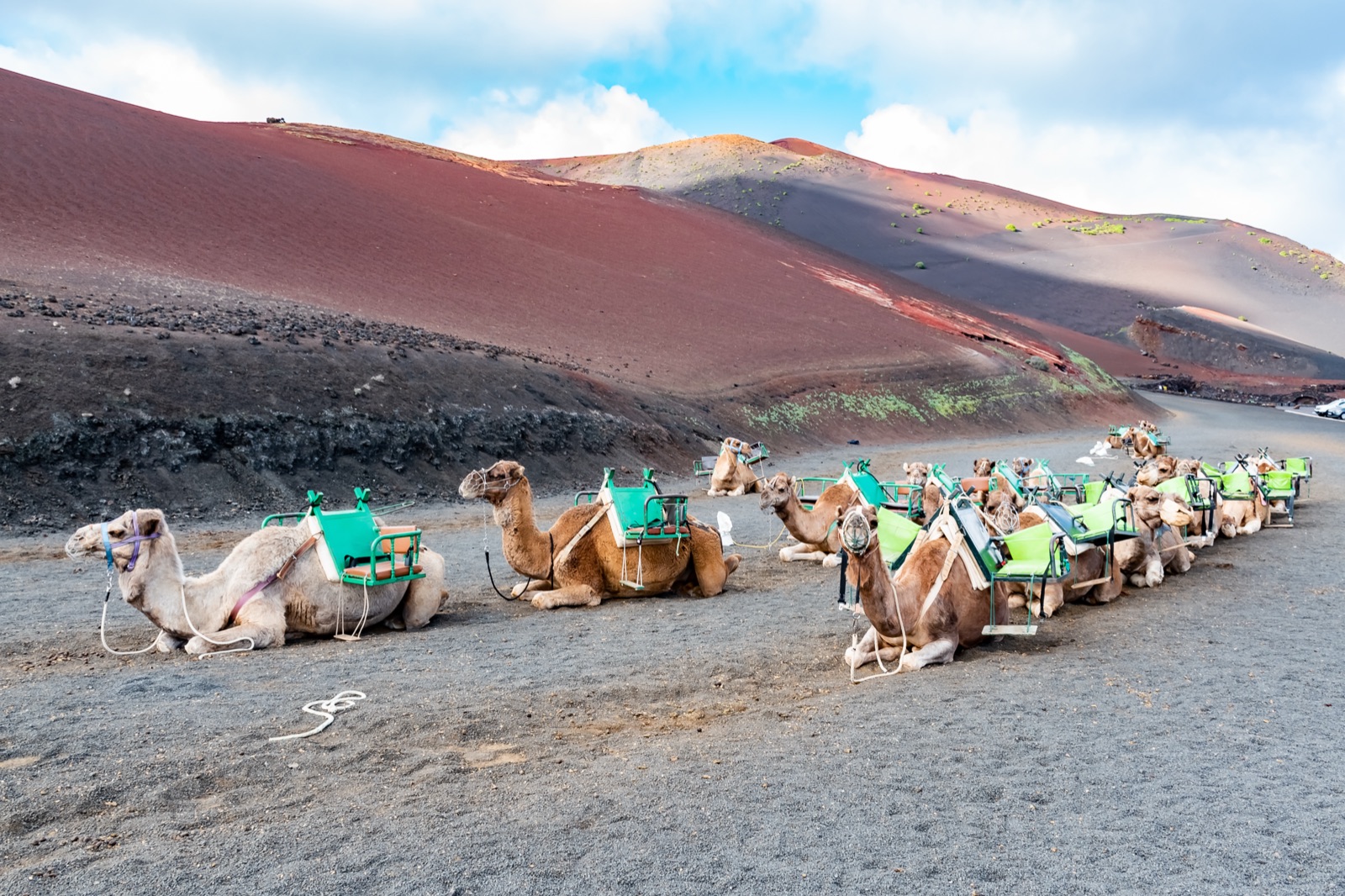
- The hornitos of the Echadero de Los Camellos, the most compact group of small volcanic structures of the whole eruption, beside the camel station on the LZ-67.
You cannot walk here. The heart of the park is seen from the Ruta de los Volcanes, a bus route that the park lists as 12 km and about 45 minutes, and on which you may not get off at any point. César Manrique and his team designed the route in the park, with a narrow road meant to cause the least physical and visual impact. There is more on that in our article on César Manrique.
The heat under Islote de Hilario
Islote de Hilario, where the Volcano Route starts, is an islote: a patch of older ground that the lava flowed around, here covered by pyroclasts from the eruption. Its real distinction is the heat. The geopark says it has the highest thermal anomalies in the Canary Islands, with the surface reaching about 250 °C and more than 600 °C at 13 m depth. The César Manrique foundation gives a slightly different figure, more than 600 degrees only 15 metres down. Either way, the rock a short way below the car park is hotter than any kitchen oven.
The Canary Islands government’s park site describes these geothermal anomalies as surface areas above 100 °C on crater rims. The most important are at Islote de Hilario, the Casa de los Camelleros and the floor of the Timanfaya crater.
At Islote de Hilario the heat is put to work for visitors. Staff pour cold water into boreholes to make artificial geysers and drop plants into a hole to watch them catch fire on their own. Beside the El Diablo restaurant at the top of the islote, an oven uses the natural heat to cook food. Stay in the marked areas; some of the ground there is very hot.
How to read the lava
Once you know what to look for, the lava fields stop being a uniform black.
- Aa lava is the viscous kind. It cools into a jagged surface that is very hard to walk on, known on the island as malpaís.
- Pahoehoe lava is more fluid. As it advances it twists into ropy lava, and it can form lava tubes, when the outside of a flow cools and solidifies while lava keeps flowing inside.
- Lapilli are small stones between 2 and 20 mm across. In the Canaries they are called picón, and on Lanzarote rofe. La Geria, east of the park, is the largest field of wind-scattered pyroclasts in the Canary Islands, and its vines use the lapilli to hold moisture.
- Volcanic bombs are lava fragments that solidified in the air while spinning, which gives them a spindle shape. Around Caldera Colorada lie many large bombs, some still sitting in their impact craters.
- Islotes are older ground surrounded by younger lava, such as Caldera Blanca and La Caldereta. They often keep plants and animals that the lava destroyed elsewhere.
- Jameos are openings left where part of a lava tube’s roof has collapsed.
Volcanoes you can walk
Inside the national park, walking is only allowed on the park’s routes. The classic one is the Ruta de Tremesana, a free guided walk of about 3 hours and 3.5 km, of low difficulty, which must be booked at least a month in advance. Our guide to walks, camels and the visitor centre covers how to book it.
Outside the national park, the Tinajo council’s trail network has three routes among the volcanoes of the eruption, all in the Parque Natural de Los Volcanes.
Caldera de Los Cuervos
This is an easy way to stand inside a volcano on Lanzarote. The trail starts at a car park on the LZ-56, the Tinguatón road, at kilometre 1.5. It is of low difficulty, suits everyone and takes about 1 hour. You walk to the base of the cone, round to its north side, and through a breach into the crater, whose walls are solidified lava and pyroclasts. Look out for the erratic block, a huge block of rock carried off by the lava when the lava lake inside the crater drained suddenly. The geopark places it about 200 m from the breach.
Montaña Colorada
A short drive along the same road, the Montaña Colorada trail starts on the LZ-56 at kilometre 2.5. It is also of low difficulty and takes about 1 hour, circling the red cone with information panels along the way. The highlight is the huge volcanic bomb on the south-east side of the cone, a single lump of lava thrown out by the last vent of the eruption. The geopark describes the same path as a self-guided trail around Caldera Colorada.
Caldera Blanca
For a longer walk, Caldera Blanca is a giant volcano with a crater more than a kilometre across. It is not a cone of 1730: it is an older islote that the lava surrounded. The route starts near Mancha Blanca, at kilometre 13 of the LZ-67, where walkers park on the dirt track 150 metres after leaving the village towards the national park. It crosses the lava to the islote of La Caldereta, then climbs to the rim of Caldera Blanca. Allow about four and a quarter hours.
A guided hike
If you would rather walk with a guide, the guided hike across the lava fields covers 9 km at an easy pace in the volcano natural park next to the national park, in about 3 hours, with an optional hotel transfer.
Rules on the volcanoes
- Stay on the marked path. The park’s site asks visitors always to walk on the same path so the landscape stays unaltered.
- Leave the stones. Do not take away volcanic material.
- No drones.
- Bring shade with you. There is nowhere to shelter from the sun in the national park, so a hat, sunglasses, sun cream and water are essential on any walk.
Lava tubes: La Corona in the north
Timanfaya’s lava formed tubes too, but the famous ones you can enter belong to a different, much older volcano: La Corona, in the north of the island. The geopark dates the eruption that formed the La Corona tube to about 25,000 years ago. The Cabildo’s tourist-centres site gives a far younger figure, about 5,000 years. We follow the geopark, whose inventory is the more specialist geological source.
The tube is more than 7.6 km long, and its last 1.6 km, the Túnel de la Atlántida, now lie below sea level. Two sections are open to visitors:
- Cueva de los Verdes, a guided walk of about a kilometre through the tube’s different levels, adapted for visitors by the artist Jesús Soto.
- Jameos del Agua, where César Manrique turned collapsed sections of the tube into a lake, a garden and an auditorium. The Casa de los Volcanes museum inside explains the tube.
Both are on the Arrieta–Órzola road, and our article on César Manrique has the practical details.
Seeing Lanzarote’s volcanoes: a simple plan
- Day one, the park: book a timed Montañas del Fuego ticket (€30 for adults), see the geothermal demonstrations at Islote de Hilario and ride the Volcano Route. The Mancha Blanca visitor centre, open daily from 9:00 to 16:00, explains the eruption before or after.
- Same day or next, on foot: walk into Caldera de Los Cuervos and round Montaña Colorada. Both trails are on the LZ-56 near Mancha Blanca, and together they take about two hours.
- A longer walk: Caldera Blanca, starting near Mancha Blanca, for a half-day on the lava.
- Another day, the north: Cueva de los Verdes and Jameos del Agua for the lava tube.
If you would rather not drive, the Timanfaya half-day tour covers the Volcano Route with a guide, the geothermal demonstrations and an optional camel ride in about 5 hours. The tours page lists the options.
Frequently asked questions
Are the volcanoes on Lanzarote still active?
The last eruption was in 1824, and the park’s history page says Lanzarote’s volcanoes have been in a period of calm since then. The heat has not gone: at Islote de Hilario the geopark records about 250 °C at the surface and more than 600 °C at 13 m depth.
When did a volcano last erupt on Lanzarote?
In 1824. The eruption began on 31 July at the Tao volcano, went on to build Chinero (Volcán Nuevo del Fuego) and Tinguatón, and ended around 25 October.
Can you walk on the volcanoes in Timanfaya?
Not freely inside the national park, where the Montañas del Fuego are seen from the Volcano Route bus and walking is limited to the park’s guided routes. In the Parque Natural de Los Volcanes next door, signed trails lead into Caldera de Los Cuervos, around Montaña Colorada and up to Caldera Blanca.
Which volcano started the 1730 eruption?
The Caldera de Los Cuervos, which formed on 1 September 1730 and destroyed the village of Chimanfaya. You can walk into its crater on a trail of about 1 hour from the LZ-56.
How hot is the ground at Islote de Hilario?
The geopark gives about 250 °C at the surface and more than 600 °C at 13 m depth. The César Manrique foundation says more than 600 degrees only 15 metres down. That heat drives the geysers and the oven at the El Diablo restaurant.
Where can you go inside a lava tube on Lanzarote?
In the north, at Cueva de los Verdes and Jameos del Agua, two sections of the La Corona lava tube. They are on the same road and easy to combine in half a day.