Places
El Golfo, Lanzarote: The Green Lagoon, Los Hervideros and Janubio
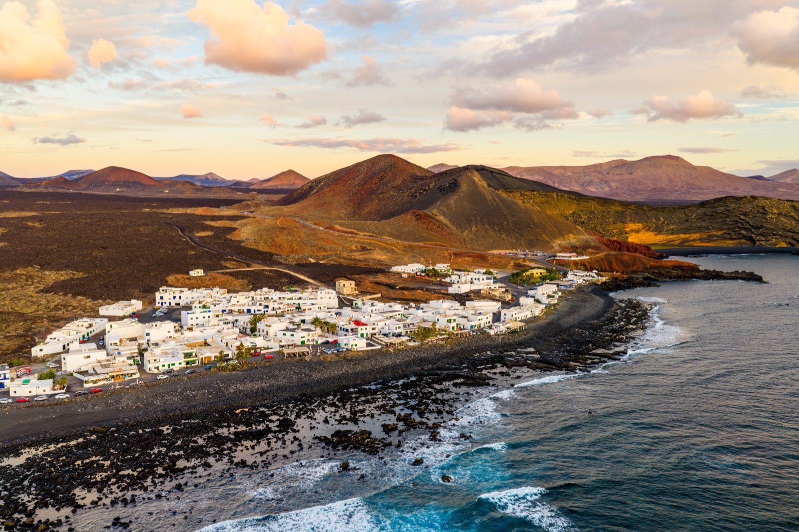
El Golfo is a small fishing hamlet on Lanzarote’s west coast, built beside a volcanic crater that the sea has cut in half. Inside that crater lies the Charco de los Clicos, the Green Lagoon, which you see from a viewpoint above: the path down to it is off limits. A little to the south, Los Hervideros is a stretch of lava cliff where the Atlantic bursts through caves and blowholes, and further south again the Salinas de Janubio are the largest salt pans in the Canary Islands. All three are in the municipality of Yaiza, close to Timanfaya.
They sit next to Timanfaya, not inside it. El Golfo, the lagoon and Los Hervideros belong to the Parque Natural de Los Volcanes, the band of protected lava that surrounds the national park, and Janubio is a protected site of its own. They are open-air places on the coast rather than ticketed centres, which makes them an easy afternoon after a morning in the Montañas del Fuego. This article explains what each place is, the rules at the lagoon, and the order and time of day that work best.
The west coast at a glance
- El Golfo: a volcano half eroded by the sea, with a fishing hamlet beside it, the only village inside the Parque Natural de Los Volcanes.
- Charco de los Clicos: the green lagoon inside El Golfo’s crater. It is a nature reserve and is seen from the viewpoint; the path down to it is prohibited.
- Los Hervideros: a cliff of eighteenth-century lava with caves, arches and blowholes, signposted paths and its own car park. It is at its best when the sea is rough.
- Salinas de Janubio: the largest salt pans in the Canaries, in a lagoon cut off from the sea by the lava of 1730–1736.
- The order: Janubio in the south, Los Hervideros in the middle, El Golfo at the northern end.
Next to Timanfaya, not part of it
Timanfaya National Park is surrounded by a second protected area, the Parque Natural de Los Volcanes. The Yaiza council describes it as a broad band around the national park, bordering the sea to the west, of about 10,158 hectares. Together with the national park, it holds one of the island’s best examples of historic lava flows and lapilli fields. The Cabildo, the island council that manages it, lists the sensitive places its plan covers: the Charco de Los Clicos, Montaña Colorada, Caldera Blanca, Volcán del Cuervo and Los Hervideros.
That matters because some guides blur the line. The Canary Islands tourism board’s page on Los Hervideros places it inside the national park; the Cabildo’s plan puts it in the natural park, and we follow the Cabildo, which manages the area. The practical upshot is simple. The strict national-park rules you meet at the El Taro entrance, where you may not stop or leave your car, do not apply on this coast road. Different rules do, and they are set out below.
The landscape is the same, though. The lava that built Los Hervideros and cut off the Janubio lagoon came from the eruptions of 1730–1736, the same eruptions that created Timanfaya. Our guide to getting to Timanfaya covers the roads into the park itself.
El Golfo: a volcano cut in half
El Golfo formed in a very different way from the lava fields around it. The Lanzarote geopark describes it as a Surtseyan volcano, a hydromagmatic eruption in which rising magma met water. Its deposits show both wet and dry pyroclastic surges: fast, ground-hugging clouds of ash and steam.
As the eruption went on, its columns of ash repeatedly collapsed and built up a tuff cone. Later the sea took its share. Erosion removed almost half of the cone, and a Strombolian eruption followed, spreading its own cinders and lava over part of what was left.
What you see today is the inside of the surviving half, a curved wall of layered ash facing the sea. Look closely at the layers and you can pick out the textbook signs of an eruption in water that the geopark lists: accretionary lapilli, small balls of ash that grew as they fell through moist air; cross-bedding; and the ripples geologists call dunes and antidunes, left by surges racing across the ground. Its colour is the giveaway. Palagonitisation, a chemical change in the volcanic glass, has turned the ash deposits the yellow and ochre that make El Golfo look so unlike the black lava fields around it. The geopark notes that viewing conditions are good from the viewpoints, and that is how most visitors see it.
The Charco de los Clicos: the Green Lagoon
At the foot of the crater wall lies the Charco de los Clicos, also called the Charco Verde or Green Lagoon. It is a small body of water that looks like a pond but belongs to the sea.
- How it works: the Yaiza council explains that the lagoon is connected to the sea by underground cracks and separated from it by a strip of beach. The geopark describes that barrier as a pebble bar.
- Why it is green: the colour comes from the large quantity of plant organisms suspended in the water, which the geopark identifies as algae. Against the black sand and the yellow cliff, the effect is striking.
- The name: clicos are edible shellfish that were once very abundant here. In the council’s account, they died out after two turtles were released into the waters of El Golfo.
- Its protection: the lagoon has been declared a nature reserve, under the same protection as the Parque Natural de Los Volcanes.
The rules at the lagoon
The lagoon is seen from above, and the Yaiza council has been pressing for the rules to be enforced.
- The path down is closed. On 8 November 2024 the Yaiza council wrote to the Cabildo asking it to replace the worn ropes that mark the areas open to the public, to signpost the ban on access properly, and to extend the rope so that nobody can reach the prohibited path that goes down to the Charco de los Clicos from the viewpoint at the El Golfo car park.
- Access to the village beach has changed too. The council’s statement also refers to an access stairway to El Golfo beach that was removed by the state coastal authority, Costas del Estado.
- Repairs and signs are pending. The same letter asked for the stairs and stone walls on one of the footpaths to El Golfo beach, which are listed as ethnographic heritage, to be repaired, and for signs setting out the code of conduct in nature and the rules of use.
- More work has been requested. In January 2026 the council again asked the Cabildo for urgent action on the area.
Some older guides and blog posts still describe walking down from the car park to the lagoon’s beach. Follow the ropes and signs you find on the day rather than a description written before the changes, and check before you go.
The general rules for protected places apply as well: do not collect or take away stones, do not pile stones into “towers”, and do not walk where it is not allowed.
El Golfo village
The hamlet of El Golfo sits on the shore beside the crater. The Canary Islands tourism board describes a fishing hamlet inside the natural park, surrounded by the lava of the 1730–1736 eruptions. Its whitewashed, flat-roofed houses line narrow streets that end at boats pulled up on a black-sand beach. The Yaiza council calls it a village of seafaring origin, and it is the only settlement inside the natural park.
Most visitors come for two things besides the lagoon:
- Fish. The village is known for food based on fresh local fish.
- The evening light. The tourism board recommends the sunset from the terraces. The coast faces west, so on a clear evening the sun goes down over the Atlantic.
El Golfo also has small-scale accommodation, which suits anyone who wants to be close to both the lagoon and Timanfaya National Park.
It is also the starting point of one of the national park’s free guided walks: the park’s booking page lists a coastal route from El Golfo, in Spanish and English, which must be booked at least a month in advance. Our guide to walks, camels and the visitor centre has the details.
Los Hervideros
The name means something like “the boiling places”, and on a rough day it fits. In the tourism board’s description, the Atlantic forces its way into the coast and rises so that the water seems to boil.
What it is
The geopark describes Los Hervideros as a cliff cut into the historic Timanfaya lava flows, on the west coast. The Yaiza council dates the caves and blowholes to the eruptions of 1730–1736, sculpted since then by erosion.
Look for three things:
- Columns. In the cliff face you can see columnar jointing, the pattern of cracks that formed as the thick lava cooled.
- Caves, arches and skylights. The sea has exploited those cracks, opening corridors for the water, skylights, arches and small caves with boulder beaches.
- Blowholes. On days of heavy swell, waves forced into the lava corridors throw up jets of spray, locally called bufaderos, several metres high.
The rock itself rewards a closer look. The lava flows are very thick here, and the geopark describes them as olivine basalt packed with dunite xenoliths: fragments of green, olivine-rich rock from deep below the island, carried up by the magma. At the surface the lava is the rough aa type, studded with large accretionary lava balls, rounded masses that rolled along inside the moving flow.
How to visit
Los Hervideros is set up for visitors, with signs, its own car park and a network of paths linking natural balconies between the blowholes. The geopark says it is very spectacular when the sea is not calm, and the Yaiza council notes that the sea usually pounds this coast with particular violence. That is the attraction and the risk.
Stay safe
- Never turn your back on the sea, the tourism board’s advice for this coast.
- Stay on the paths. The lava is sharp and uneven, and the sea has hollowed out the cliff below the balconies.
- Wear closed shoes. Sandals and lava do not mix.
- Keep children close at the balconies, especially when spray is breaking over the rocks.
Salinas de Janubio
South of Los Hervideros, the Salinas de Janubio are a patchwork of evaporation ponds in a lagoon behind the shore. The geopark tells their story in three stages.
- A harbour. The site was once the Puerto Real de Janubio, a natural inlet.
- A lagoon. The eruptions of 1730–1736 changed the coast. Material eroded from the new lava was carried along the shore and built a bar of rounded boulders that closed the inlet, leaving the coastal lagoon you see today.
- A salt works. The geopark dates the salt pans to 1895 and calls them the largest salt pans in the islands and those of the greatest scenic value. Salt at Janubio has always been produced by artisanal methods, without mechanisation.
The geopark adds that the salt pans have been tied to fishing from the start, supplying the fish-salting and canning industry, and it counts Janubio among the most important salt works in the world. The geopark also points out marine platforms of Tortonian and Pliocene age here, old wave-cut shorelines far older than the lagoon.
The Yaiza council describes Janubio as the largest and most important salt-pan complex in the archipelago. The pans are laid out in steps that follow the edges of the lagoon. Water was once lifted from the lagoon by five sail windmills, later replaced by motors, and carried to the different pans through a network of channels. The lagoon is also an important refuge for many wading birds, including many migrants, and the site is protected as a special protection area for birds and a Paraje Natural de Interés Nacional. The council notes that seabird communities add to the scientific value of the area. Bring binoculars if you have them.
Driving order and timing
The three places line up along the coast. In the tourism board’s description, Los Hervideros forms a triangle with the Salinas de Janubio to the south and the Charco de los Clicos at the northern end.
Coming from the south of the island, the natural order is Janubio first, then Los Hervideros, then El Golfo, finishing in the village for an early dinner.
Coming from Timanfaya, reverse it: El Golfo first, then south along the coast to Los Hervideros and Janubio.
A few timing tips:
- Los Hervideros is best in a swell. If the sea is flat, the blowholes will be quiet, though the cliffs are still worth the stop.
- El Golfo is best late in the day. The low sun lights the crater wall and the lagoon, and the terraces fill for sunset.
- Pair it with Timanfaya. The Montañas del Fuego need a timed ticket; a morning slot leaves the afternoon for this coast. The getting-there guide suggests the same loop.
- Expect company. The Yaiza council says the El Golfo area is carrying a heavy load of visitors without infrastructure built for them, so the viewpoints can be crowded in the middle of the day.
If you would rather not drive, the Timanfaya and La Geria tour covers the Volcano Route and the geothermal demonstrations, then the La Geria vineyards and the Green Lagoon at El Golfo, in about 5.5 hours. The Timanfaya half-day tour, about 5 hours, covers the park itself. The tours page lists both.
Practical tips for the coast
- Drive and park. These are car stops: Los Hervideros has its own car park, and the El Golfo viewpoint is reached from a car park by the village.
- Dress for wind and sun. The west coast is exposed, and there is little shade at any of the three stops.
- Wear closed shoes. The paths at Los Hervideros cross rough lava, and the ground around the viewpoints is volcanic and uneven.
- Leave nothing and take nothing. No stones, no stone towers, no litter. The lagoon is a nature reserve and the whole coast is protected.
- Look, then eat. See the lagoon from the viewpoint before sunset, then keep El Golfo’s terraces for the evening.
Frequently asked questions
Can you walk down to the Green Lagoon at El Golfo?
No. The lagoon is seen from the viewpoint above. The Yaiza council has asked the Cabildo to rope off the prohibited path that goes down to the Charco de los Clicos from the viewpoint at the El Golfo car park. Follow the ropes and signs on the day.
Is El Golfo part of Timanfaya National Park?
No. El Golfo, the Charco de los Clicos and Los Hervideros are in the Parque Natural de Los Volcanes, the protected band of lava that surrounds the national park. They are close to Timanfaya and shaped by the same eruptions, but the national park’s access rules do not apply there.
Why is the Charco de los Clicos green?
Because of the large quantity of plant organisms, which the geopark identifies as algae, suspended in the water. The lagoon is connected to the sea by underground cracks and separated from it by a strip of beach.
When is the best time to see Los Hervideros?
When there is a swell. On days of heavy sea, waves forced into the lava corridors throw jets of spray several metres high. Keep to the paths and never turn your back on the sea.
How old are the Salinas de Janubio?
The geopark dates the salt pans to 1895. The lagoon they sit in formed after the eruptions of 1730–1736, when a bar of boulders closed the old Puerto Real de Janubio.
How much time do El Golfo, Los Hervideros and Janubio need?
An afternoon covers all three by car, with time for a meal in El Golfo. They pair well with a morning visit to the Montañas del Fuego.